FAA's Hurricane Irma Update (ingles\español)

FAA logo

News & Update

You are subscribed to News & Updates from the FAA Homepage. This information has recently been updated, and is now available.

Map of Hurricane IrmaTwitter Social Media ButtonFacebook Social Media Button

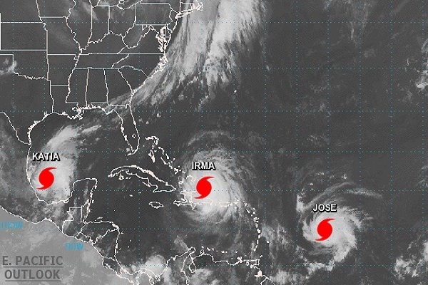
FAA's Hurricane Irma Update (ingles\español)


September 7 - The Federal Aviation Administration (FAA) closely monitors forecasted hurricanes and severe weather events and prepares FAA facilities and equipment to withstand storm damage. We prepare and protect air traffic control facilities along the projected storm path so we can quickly resume operations after the hurricane passes. Enabling flights to resume quickly is critical to support disaster relief efforts.


FAA control towers in hurricane-prone areas are designed and built to sustain hurricane force winds. Each control tower has a maximum wind sustainability. When the winds approach that level, controllers evacuate the tower cabs. They may remain in the building on duty in a secure lower level, and are ready to go back to work as soon as the storm passes.


We also protect communications equipment and navigational aids to the greatest extent possible. As the storm approaches, we disable airport surveillance radar antennas to allow them to spin freely, minimizing potential wind damage. This limits damage to the antenna motors and allows radar coverage to resume quickly after the storm passes.


Airports and associated facilities including terminal buildings, parking lots and access roads are operated by local organizations that decide when to close to commercial operations and when they can safely reopen. The FAA does not decide if or when airports or other local facilities close or reopen. Some airports in a disaster area may stay closed to the public for several days in the wake of a storm to support the response and recovery effort or because roads to and from the airport are inaccessible. FAA air traffic controllers always are ready to safely resume air traffic control service when airports reopen, and frequently are managing air traffic operations for response and recovery flights while airports are closed to the general public.


Commercial Travelers
Due to Hurricane Irma, airlines are likely to cancel many flights in the direct path of the storm and the surrounding area. Flights that are not cancelled may be delayed. Please continue to check the status of your flight with your airline. You can also check the status of some major airports in the storm path by visiting Fly.FAA.gov, which is continuously updated.


Drone Users
The FAA warns unauthorized drone operators that they may be subject to significant fines if they interfere with emergency response operations. Many aircraft that are conducting life-saving missions and other critical response and recovery efforts are likely to be flying at low altitudes over areas affected by the storm. Flying a drone without authorization in or near the disaster area may unintentionally disrupt rescue operations and violate federal, state, or local laws and ordinances, even if a Temporary Flight Restriction (TFR) is not in place. Allow first responders to save lives and property without interference.


Government agencies with an FAA Certificate of Authorization (COA) and private sector Part 107 drone operators who want to fly to support of response and recovery operations are strongly encouraged to coordinate their activities with the local incident commander responsible for the area in which they want to operate.


If UAS operators need to fly in controlled airspace or a disaster TFR to support the response and recovery, operators must contact the FAA for authorization. Each TFR has the appropriate contact information.


General Aviation Pilots

General aviation pilots should check the FAA's Notices to Airman (NOTAMs) before flying and review the latest information on flight restrictions in the areas affected by Hurricane Irma. You can monitor TFRs at TFR.FAA.gov and @FAANews on Twitter for the latest information. Regardless of where you are flying, always be aware of the weather conditions along your entire planned route. Contact your destination airport before you take off to obtain the most current information about local weather and airfield conditions. Remember that standard check lists are even more important in and around severe weather. Be aware of weather conditions throughout the entire route of your planned flight. A pilot's failure to recognize deteriorating weather conditions continues to cause or contribute to accidents.


Spanish Version


La Administración Federal de Aviación (FAA) monitorea muy de cerca los pronósticos de huracanes y eventos climáticos severos y prepara instalaciones de la FAA y el equipo para soportar el daño de la tormenta. Preparamos y protegemos las instalaciones de control de tráfico aéreo a lo largo de la ruta proyectada de la tormenta por lo que rápidamente podemos reanudar las operaciones tras el huracán. Lo que permite reanudar los vuelos rápidamente lo cual es fundamental para apoyar los esfuerzos de ayuda.

Las torres de control de la FAA en áreas propensas a huracanes se diseñan y son construidas para sostener los vientos huracanados. Cada torre de control tiene una sustentabilidad máxima del viento. Cuando los vientos acercan a ese nivel, los controladores son desalojados/pasan a otras partes de la torre. Ellos pueden seguir prestando los servicios en el mismo edificio, pero en un nivel inferior seguro y están listos para volver al trabajo tan pronto como pase la tormenta.

También protegemos los equipos de comunicaciones y asistimos a la navegación en la mayor medida posible. Mientras la tormenta se acerca, desactivamos las antenas de radar de vigilancia del aeropuerto para que puedan girar libremente, y minimizar el daño potencial de viento. Esto limita el daño a los motores de antena y permite una cobertura del radar para que este se reanude rápidamente después de que la tormenta pase.

Los aeropuertos y los servicios asociados incluyendo edificios terminales, estacionamientos, vías de acceso, etc., son operados por organizaciones locales que decidan cuándo cerrar y cuándo puede abrir con seguridad.  La FAA no decide cuando los aeropuertos u otras instalaciones locales cierran o abren.  Los controladores de tráfico aéreo de la FAA siempre están listos para reanudar el servicio de control de tráfico aéreo con seguridad cuando los aeropuertos están abiertos y operando.

Viajeros comerciales

Debido a Huracán Irma, las líneas aéreas suelen cancelar numerosos vuelos en la ruta directa de la tormenta y sus alrededores. Los vuelos que no se cancelan pueden retrasarse. Por favor continúe verificando el estado de su vuelo con su compañía aérea. También puede verificar el estado de algunos aeropuertos importantes en la trayectoria de la tormenta al visitar fly.faa.gov, que se actualiza regularmente.


Sistema Aéreo no tripulado UAS\Drone
La FAA advierte a los operadores de sistemas aéreo no tripulado UAS\Drone   no autorizados que pueden estar sujetos a multas importantes si interfieren con las operaciones de ayuda a emergencias. Un vuelo de un Drone sin autorización en o cerca de la zona de desastre puede violar las leyes federales y ordenanzas estatales, aunque sea un Restricción Temporal de Vuelos (TFR, por sus siglas en inglés)) no está en su lugar. Permite a los primeros rescatistas salvar vidas y bienes sin interferencia.


Los operadores de UAS que necesitan volar en el espacio aéreo controlado o un TFR de desastre para brindar el apoyo y ayuda necesaria de recuperación deben contactar la FAA para autorización. Cada TFR tiene la información de contacto apropiada. 


Pilotos de aviación general

Pilotos de aviación general deben verificar los Avisos a Aviadores (NOTAMs) de la FAA antes de volar y revisar la información más reciente sobre las restricciones de vuelo en las zonas afectadas por huracán Irma. Para la información más reciente pueden monitorear los TFR's desglosada en TFR.FAA.gov , @FAANews y en Twitter. Independientemente de donde usted está volando, siempre ten en cuenta las condiciones meteorológicas a lo largo de su ruta prevista. Póngase en contacto con su aeropuerto de destino antes de despegar para obtener la información más actualizada sobre las condiciones locales de clima y aeropuerto. Recuerde que las listas estándar de verificación son aún más importantes en los alrededores de tiempo severo. Ser conscientes de las condiciones meteorológicas a lo largo de todo el recorrido de su vuelo planeado. La falla del piloto para reconocer el deterioro de las condiciones de tiempo continúa a causar o contribuye a los accidentes.


Please do not reply to this message. See our Contact FAA page for contact information.


This email was sent to sajanram.shrestha@blogger.com using GovDelivery Communications Cloud on behalf of: U.S. Federal Aviation Administration · 800 Independence Avenue, SW · Washington, DC 20591 · 1-866-TELL-FAA (1-866-835-5322) GovDelivery logo

U.S. Department of Transportation Announces $151.1 Million in Infrastructure Grants to 66 Airports in 35 States

FAA Press Release
FAA logo

Press Release

For Immediate Release

Date: September 7, 2017

Contact: Marcia Alexander-Adams

Phone202-267-3488; Email: marcia.adams@faa.gov 

You are subscribed to News updates for the Federal Aviation Administration. A new Press Release is now available. We've included a copy of the release in this email.

Airports GrantsTwitter Social Media ButtonFacebook Social Media Button

U.S. Department of Transportation Announces $151.1 Million in Infrastructure Grants to 66 Airports in 35 States


WASHINGTON – U.S. Department of Transportation Secretary Elaine L. Chao today announced the Federal Aviation Administration (FAA) will award $151.1 million in airport infrastructure grants to 66 airports in 35 states across the United States as part of the FAA's Airport Improvement Program (AIP).

"The Airport Improvement Program helps to maintain our aviation infrastructure and supports safety, capacity, security and environmental improvements," said Secretary Chao.  "This is an important investment in these airports and the economic vitality of their respective communities."

The airport grant program funds various types of airport infrastructure projects, including runways, taxiways, and airport signage, lighting, and markings, all of which help to create thousands of jobs.

To date this year, the U.S. Department of Transportation has announced more than 1,500 new grants to nearly 1,300 airports for a total of $2.5 billion.  These grants will provide funds for 620 runway projects and 533 taxiway projects that are important to safety and efficiency of the nation's system of airports.     
 

Airports are entitled to a certain amount of AIP funding each year, based on passenger volume. If their capital project needs exceed their available entitlement funds, then the FAA can supplement their entitlements with discretionary funding.

Those airports receiving discretionary grants are listed here, while the entitlement grant recipients (PDF) can be found on our website.


Bob Baker Memorial Airport in Kiana AK, $5.9 million – funds will be used to expand the existing apron and extend Runway 06/24 by 600 feet.


Ithaca Tompkins Regional Airport in Ithaca, NY, $1.4 million – funds will be used to repair the apron where the aircraft park.

Range Regional Airport in Hibbing, MN, $3.5 million – the grant will be used to repair Taxiway C and replace the taxiway lighting.

Hillsboro Municipal Airport in Hillsboro, ND $4.3 million – funds will be used to repair Runway 16/34.

Joe Foss Field in Sioux Falls, SD, $8.3 million – funds will be used to repair Runway 03/21.

Portland International Jetport in Portland, ME, $1.3 million –funds will be used to improve the airports energy efficiency by installing equipment such as solar panels.

Asheville Regional Airport in Asheville, NC, $5 million – grant funds will be used to repair Runway 17/35.

Chennault International Airport in Lake Charles, LA, $4.7 million – funds will be used to repair Runway 15/33.

San Antonio International Airport in San Antonio, TX, $5.6 million – grant funds will be used to repair Taxiway R.

Guam International Airport in Tamuning, GU, $3.5 million – funds will be used to construct an aircraft rescue and firefighting building.

Southern California Logistics Airport in Victorville, CA, $7.3 million – grant funds will be used to repair Runway 17/35.

Laughlin/Bullhead International Airport in Bullhead City, AZ, $8.2 million – funds will be used to reconstruct multiple aircraft parking aprons.

Scottsdale Airport in Scottsdale, AZ, $3.9 million – grant funds will be used to repair Taxiway A.

Arcata Airport in Arcata, CA, $5.9 million – grant funds will be used to construct an aircraft rescue and firefighting building.

The grants will ensure the projects at these airports are either under construction or completed prior to the onset of the winter season.

###

Please do not reply to this message. See our Contact FAA page for contact information.


This email was sent to sajanram.shrestha@blogger.com using GovDelivery Communications Cloud on behalf of: U.S. Federal Aviation Administration · 800 Independence Avenue, SW · Washington, DC 20591 · 1-866-TELL-FAA (1-866-835-5322) GovDelivery logo

FAA Small Drone Rule Lets Unmanned Aircraft Soar

FAA News & Update
FAA logo

News & Update

You are subscribed to News & Updates from the FAA Homepage. This information has recently been updated, and is now available.

FAA Administrator Huerta speaking at InterDrone Conference in Las VegasTwitter Social Media ButtonFacebook Social Media Button

FAA Small Drone Rule Lets Unmanned Aircraft Soar

September 6 – A host of new users is changing the world of commercial aviation thanks in large part to the Federal Aviation Administration's (FAA) small unmanned aircraft rule, Part 107 (PDF), which has now been in place for a year.  Under the new regulations, drones are changing the way countless jobs are done, from movie filming and real estate marketing to agricultural mapping and smokestack inspections.

The numbers tell part of the success story. Since the Part 107 rule became effective last August, more than 80,000 individual drones have been registered for commercial and government purposes. And more than 60,000 people have obtained a Remote Pilot Certificate required to operate a drone under Part 107.

The FAA's Part 107 is making is possible for a broad range of entities to find innovative uses for drones. Take a look at these examples.

Responding to Disaster – Hurricane Harvey
Drones have been invaluable in supporting response and recovery efforts for Hurricane Harvey. The FAA has issued 127 authorizations to drone operators performing seach and rescue missions and  assessing damage to roads, bridges and other critical infrastructure; sometimes the agency has issued these authorizations within a few hours. In addition to the direct response and recovery efforts, several media outlets are operating drones over Houston to provide coverage to local residents and the world about flooding and damage in the area. All drone flights are carefully coordinated with manned aircraft operations to ensure the safety of everyone using the crowded Soth Texas airspace.

FAA Administrator Michael Huerta addressed the agency's response to the "transformative role" drones are playing in Hurricane Harvey recovery operations in today's remarks to the InterDrone conference.

Commercial use of drones is taking off.
Several major property insurance companies are using drones to examine homes after storms, capturing images and video in crystal clear quality without requiring a person to climb up to a potentially hazardous roof. Dozens of television stations around the country fly drones to bring fresh aerial views of breaking news at lower risk and cost than a typical news helicopter. Other commercial operators of unmanned aircraft are flying them to monitor construction sites, create topographical maps, survey vegetation and drainage on farm land, inspect pipelines and other gas facilities, and many other innovative tasks.

States and municipalities are using drones for infrastructure improvements.
The Louisiana Department of Transportation and Development is saving the state hundreds of thousands of dollars by using drones to survey the median of I-10 for a cable barrier project. Officials in Minnesota and Ohio have flown drones to inspect highway bridges. And a company working with Hartsfield-Jackson International Airport is using a drone to 3-D map the runways in about half the time as teams armed with cameras.

Drones are a valuable tool for first responders.
When combating structure fires, the Wayne Township Fire Department near Indianapolis flies drones to provide a valuable perspective on hot spots and other potential hazards. In the area around Fort Collins, CO, several law enforcement and fire departments have launched a regional drone program to assist in investigations, including serious crashes and backcountry search and rescue operations. The Idaho State Police are using unmanned aircraft to get birds-eye views of crash and crime scenes, including barricade situations, fatal accidents, hazardous materials spills, and natural disasters.

Scientific research gets a boost from drones.
At the U.S. Geological Survey, officials have mounted sensors on drones to gather more accurate data than satellite imagery for the large swaths of land the USGS is responsible for monitoring. The National Oceanic and Atmospheric Administration has a fleet of 54 unmanned aircraft ranging in wingspan from less than six feet to more than 115 feet; the drones collect data from areas that can be dangerous for humans, such as the poles, oceans, wildlands, volcanic islands, and wildfires. Researchers at Oklahoma State University are flying sensor- and camera-equipped drones into developing storms to acquire measurements during tornado formation that will help improve knowledge of how tornadoes form and increase the confidence in issuing tornado warnings.

Part 107 as it now exists isn't the end of this success story. The FAA is using a risk-based approach to enable increasingly more complex UAS operations, including operations over people, operations beyond visual line-of-sight, and transportation of persons and property. The agency is capitalizing on each incremental step, making sure a framework of performance-based regulations can easily accommodate change while maintaining the United States' unmatched aviation safety record. By 2021 – just four years from now—the agency estimates there could be as many as 1.6 million small drones (under 55 lbs.) in commercial operation.

As FAA Administrator Michael Huerta said in a recent speech, "The only limitation seems to be: How quickly we – all of us, across the industry – can make it happen, safely."

Please do not reply to this message. See our Contact FAA page for contact information.


This email was sent to sajanram.shrestha@blogger.com using GovDelivery Communications Cloud on behalf of: U.S. Federal Aviation Administration · 800 Independence Avenue, SW · Washington, DC 20591 · 1-866-TELL-FAA (1-866-835-5322) GovDelivery logo